
Main menu
You are here
Land-use change
The model illustrates three types of submodel and is an example of a spatial model implemented in Simile. It shows that Simile is capable of handling quite complex spatial behaviour — in this case, landuse change in which the neighbours of a patch influence the likelihood of transition from one landuse state to another — even though Simile has no built-in constructs for spatial modelling.
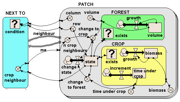
The model illustrates three types of submodel:
- The PATCH submodel is a fixed-membership, multiple-instance submodel, and is used to represent the fact that there are many landuse patches. Each patch has row and column attributes, and each one is engineered to have a unique combination of values between 1 and 20, thereby defining each one’s position on a grid. (But to drive home the point: Simile understands nothing from the labels “row” and “column”: it is up to us, the modellers, to ensure that these are given values which can be used as grid co-ordinates.)
- The FOREST and CROP submodels are contained inside the PATCH submodel. Therefore, each patch can (potentially) contain both a forest and a crop submodel. However, note that each one is a conditional submodel: see the question-mark “condition” symbol in the top-left of each one, and note the little rows of dots leading from the bottom-right edges. This indicates that the submodel may exist in only some of the patches, not all of them. In fact, the conditions are engineered so that each patch contains only forest or crop, not both (but it would be quite possible for us to have some agroforestry patches containing both, if that’s what we wanted.)
- Finally, the NEXT TO submodel is an association submodel, defining an association (relationship) between some patches and others. We can see that this is an association between patches by the presence of the two broad grey arrows (role1 and role2), pointing from the PATCH submodel to the NEXT TO submodel. As the name suggests, this association defines which patches are next to which other patches. Again, it has a condition symbol, which is used to indicate under which conditions the association holds. We note that this has influences coming from the row and column variables in the PATCH submodel: the condition is true when the row and/or column value for one patch is one away from the row and/or column value of another patch.
The model works as follows. Each patch contains a state variable (the compartment “state”) which defines the state it starts off in. This is 1 for forest and 2 for crop. If a crop patch has been a crop patch for a certain length of time, then it is abandoned and reverts to forest (as mediated by the variable “change to forest”). If the volume of the trees exceeds a certain amount and the patch has crop neighbours (this is why we need to know which patches are next to which others), then the forest is cleared and it changes to crop as the landuse (as mediated by the variable “change to crop”).
The following figure show how the model behaves, using Simile’s grid map display to show the patches on a spatial basis. The light (yellow) squares represent the patches under crop; the dark (green) squares represent forest. When users request this display, they are required to specify a variable indicating the column number for each patch, and the actual variable to be displayed: Simile then has sufficient information to lay the patches out in the correct grid-based manner. This display shows how Simile can handle spatially-referenced information, even though it has no built-in concept of spatial modelling.

Initially, most of the area is forest, with a band of cropping land on the left. After 40 years, patches of forest on the forest margin have been cleared, leading to a ragged edge to the forest boundary. In this particular run, the model was set up so that there was no reversion of cropped land back to forest, but as indicated above it has been designed to allow for this to happen.
Download the model file from the model catalogue entry to see how the spatially-explicit model is formulated.