FLORES: Flexible, Land-use Oriented Resource Envisioning System
FLORES is an international programme of research which aims to improve the livelihood of the rural poor at the forest margin, through the development of models that can be used to assess the likely i mpact of alternative policy options.
Typically, FLORES models combine biophysical aspects (crops, trees and so forth) with human socio-economics and decision-making at the household level.
Simile is used as the modelling environment for FLORES, since it has the required expressiveness for the complex modelling involved, the computational efficiency needed to run the highly-disaggregated models, and the intuitive user interface needed for a participatory modelling approach.
The aim of FLORES is to improve the livelihoods of the rural poor. It seeks to do this by developing tools to enable those responsible for formulating policy to explore the possible impacts of alternative policy options.
FLORES is a user-oriented framework for rigorously exploring alternatives that can be calibrated to various situations, and tested against empirical data. It is implemented as a participatory modeling process that has a simulation model as an outcome of each iteration.
FLORES is built on the notion that there is no need to reinvent the wheel, existing knowledge is explicitly incorporated, integrated and acknowledged through the use of participatory modeling and a growing library of easily interchangeable sub-models.
Why was Simile chosen for FLORES modelling?
Simile was chosen for the implementation of FLORES because it was considered to meet a larger number of the requirements of FLORES than other candidate approaches.
- The fact that it is a visual modelling environment increases the extent to which various contributors to FLORES development (ranging from anthropologists and economists to crop and forest modellers) can participate in the process of model construction and interpret the model design decisions made by others.
- Its ability to handle basic System Dynamics concepts (stocks, flows, intermediate variables) makes it straightforward to implement the many standard biophysical models cast in these terms.
- It has powerful features for representing the complex disaggregation, object-orientation and relationships required for FLORES: multiple patch objects, dynamically-varying numbers of households, households nested inside villages, and tenure relations between households and patches.
- It can generate highly-efficient implementations of complex models (in compiled C++), essential for a model intended to deal with the interactions within and between hundreds of households and thousands of patches.
- Its support for modular modelling means that separate groups can develop submodels, which can then be combined to make a composite model.
- All output displays are customisable (through programming in the interpreted scripting language, Tcl/Tk), making it possible to engineer interfaces to GIS and displays specific to the requirements of FLORES.
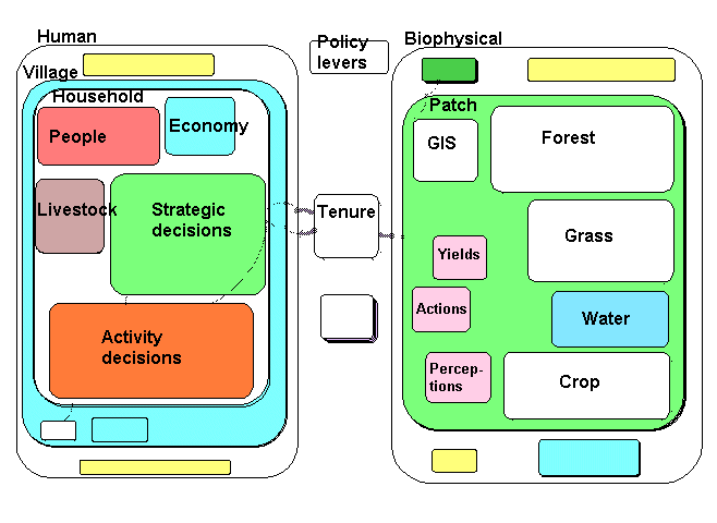
FLORES models typically have the following architecture:
- Human interactions, or the “left hand side” of the model. Here we find the human dimension of the landscapes we are interested in. Elements of this side of the model can range from individuals to districts. They are usually nested to reflect hierarchy concepts.
- Patches of landscape, or the “right hand side” of the model. These are the biophysical elements of the landscape. Each patch will have a unique identity (e.g. a polygon in a GIS) with its own characteristics. Thus it might carry a crop, grassland, forest or woodland, a fallow, etc. It can change its form of vegetation through dynamic interaction with neighboring patches and the human side of the model.
- Tenure relationships, the bridge between the left and right hand side of the model. Here we can link households uniquely to the patches of land they own, share, have access to, or are excluded from.
- Policy levers for changing model inputs. Usually placed at the top of the model diagram, these are variables that reflect external interventions (such as a subsidy for fertilizers) or scenario variables, such as a drought.
- Indicators are the means by which we can study this response. Usually placed at the bottom of the model diagram they can be defined as any variable in the model.
FLORES links
- A Symposium on Participatory Modelling, held in Harare, Feb 2002, included several papers on FLORES modelling.
- Volume 2 of the journal Small-scale Forest Economics, Management and Policy is a special issue on participatory modelling, and includes papers describing the Zimbabwe FLORES model, the Cameroon FLORES model, and the modelling of human decision-making in FLORES models.
- A web-based Powerpoint presentation on FLORES describes the motivation for FLORES, and the concepts on which it is based.
ZimFLORES: FLORES model developed for the Mafungausti State Forest, Zimbabwe
The Mafungautsi State Forest is located in central Zimbabwe, near the town of Gokwe. Considerable numbers of people live next to the forest, and there is considerable pressure to exploit the forest resources: primarily fuel wood, poles for construction, and grass for thatch in the vlei (annually-flooded river beds).
|
CIFOR has been undertaking research in the area for a number of years, concentrating on the relationship between the people, the forest resources, and the Forestry Commission, as part of the ACM project. They decided to take a lead role in developing a FLORES model for this context, based on a several villages on the north-west margin of the forest for which they had socio-economic data. The model was based on an earlier version of the FLAC training model, adapted by the addition of crop and water submodels on the biophysical side, and the development of a novel strategic decision-making submodel. The process of adapting the training model was undertaken with outside assistance, primarily in four FLAC workshops held between Sept 2000 and February 2001, in response to design requirements specified locally. The model was further refined in April 2001 as a demonstrator for the World Bank Rural Week meeting, held in Washington DC, 23-26th April 2001. |
Acronyms and Links ACM: the CIFOR-led Adaptive Co-Managament project CGIAR: Consulatative Group for International Agricultural Research, an umbrella organisation for a number of international institutes concerned with agriculture and natural resources. CIFOR: the Centre for International Forestry Research, a CGIAR centre FLAC: The FLORES Local Adaptation and Calibration package, which aims to enable local groups to make their own FLORES models. FLORES: Forest Land-Oriented Resource Envisioning System, an international programme concerned with modelling the interaction between people and their land resources at the forest margin. |
Structure
The overall structure of the model is shown in the submodel diagram, which was taken directly from the Simile implementation of the model.
The model conforms closely to the standard FLORES model, with a left-hand Human component and a right-hand Biophysical component. Inside the human submodel three villages are represented, with each village containing a variable number of households. The number of households increases when a family moves into the area, and decreases when a household dissolves because of, for example, the death of the only male adult. The biophysical side is represented in terms of a large number (900+) patches, based on the digitisation as polygons of the field boundaries from an aerial photograph.
The dynamics and behaviour of each household is modelled in five submodels:
- The submodel People models the changing population dynamics within the household, as children are born and household members die. It does this using a compartment-flow approach for each of four classes: children, adult males, adult females and elderly people.
- The submodel Economy models the economic status of the household, in terms of a single currency (“dosh”, or daily ordinary subsistence per household), which puts all household resources on a common basis.
- The submodel Livestock represents the dynamics of the household’s herd of livestock. It is placed here, rather than in the Biophysical submodel, since each household has its own herd.
- The submodel Strategic decisions is responsible for determining each household’s lifestyle strategy. This is represented in terms of the relative priority given by the household over the coming year to each of seven activities (such as growing maize, growing cotton, or pole collection).
- The submodel Activity decisions is responsible for determining the household’s week-by-week decisions. These primarily relate to the allocation of the household's labour resources to various activities, but include non-labour decisions, such as choice of crop to plant and allocation of cattle to grazing land.
The dynamics on the biophysical side is modelled in terms of four components:
- The Forest submodel calculates the dynamics of the miombo woodland in the State forest land. It is based on a model developed prior to FLORES in a workshop held in Zimbabwe, and represents the forest in terms of the number of trees in each of four classes: gullivers, poles, medium trees and large trees. It includes the reversion of trees to earlier classes if there has been a fire.
- The Grass submodel is also based on one developed in the same workshop. Its main relevance is in providing grass for thatch, but it also has a role in cattle grazing.
- The Water submodel is used to influence the growth of grass, since occasional drought years have a major influence on the people and their livelihoods.
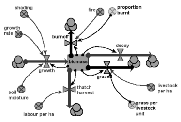
- The Crop submodel is rather special. Three types of crop are allowed for: a food crop (maize); a cash crop (cotton); and vegetables (home garden). Any one patch can have only one of these, and the allocation of a crop to a patch is determined in the strategic decision-making submodel of the household that owns the patch. The following diagram illustrates the generic crop model used.
The GIS submodel contains fixed patch-level attributes (e.g. area, soil type), as well as the boundary coordinates for display purposes.
Households and patches are joined by a Tenure association. This allows for two types of tenure: (1) ownership of a patch by a household; and (2) access to common land. The main role of the tenure association is to channel information flows from patch to household and vice versa. Three types of information are transferred:
- Perceptions carry information about the patches they own to the households that own them.
- Actions carry information on the households weekly decisions from household to the patches they own.
- Yields carry information on the amount of produce harvested from patches to the households that own them.
Using the model
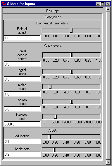
The model is set up with a Control Panel that enables you to set various policy options. You simply move the sliders and continue running or restart the model .
The behaviour of the model can be displayed using a number of display tools, including graphs and maps. T he following diagrams are for illustrative purposes.
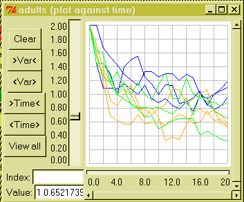
The two graphs below show how the model can be used to investigate how the community responds to changes in healthcare. The first shows the changes in the average number of adults per household in each of three villages. The orange lines show the standard run of the model. The blue lines reflect the effect of improved healthcare and health education: there is a slight improvement in the average household size. The green lines are for an increased incidence of AIDS: not a policy lever as such, but still something that the user of the model might wish to explore.
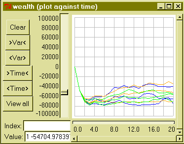
The following graph is for the same three cases, but shows wealth per household (in each of the three villages). No obvious effect of the healthcare/education policy is apparent, probably because a decrease in mortality is balanced by a decrease in resources per household.
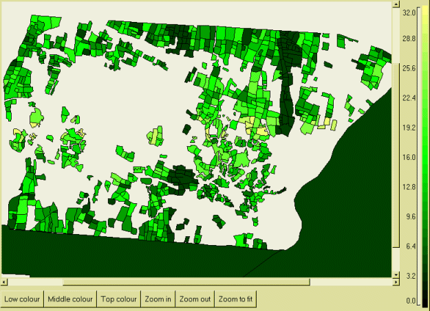
This map shows how indicators of performance can be displayed spatially. The solid dark area is part of the Mafungautsi State Forest. The small polygons are fields in the Batanai village: at the time this was prepared, only about half of the field boundaries had been digitised. The colour shows variations in crop productivity, with lighter areas indicating higher crop productivity running from left to right through the centre, with lower productivity on the higher (hence drier) land above and below this belt.
References
- ZimFlores: A Model to Advise Co-management of the Mafungautsi Forest in Zimbabwe
- Modelling Decision-making in Rural Communities at the Forest Margin